
Pillar sub-scores
A pillar mixes what is endured and what is chosen; a grade is not the average of the pillars.Missing: PUE (announced energy efficiency), Waste-heat recovery — commitment.
Missing: Cooling technology + announced water volume.
Missing: Ecological corridors (TVB), Site ground footprint, Avoid-reduce-offset (ERC) measures, Designated for urbanisation in a supra-municipal plan, Planning-document compatibility procedure under way.
Missing: Absorption capacity (project size vs municipality), Announced jobs, Announced tax revenue, Observed level of opposition, Elected officials' position (voted facts only).
“Rated C on site, but E on “Energy”.”
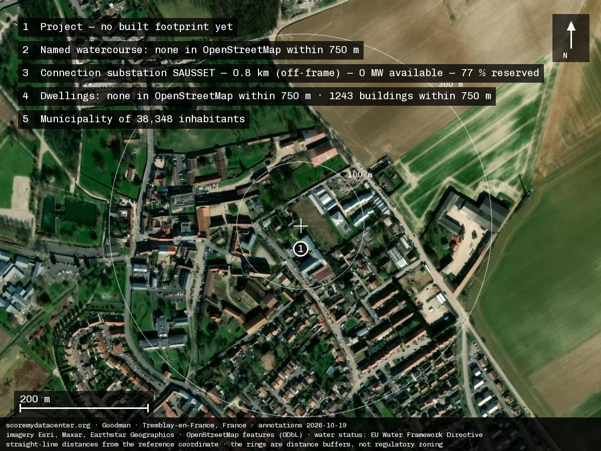
This site is among the 80% of the fleet connected to an already-saturated substation. Fleet figures →
This site is in France — the country's site index: C (55.9). See the country index →
What the environmental case file states
2023-11-02 · 30 pages · read the opinion (PDF)
Energy and heat
Grid connection voltage225 kVp.2
Le projet intègre également le raccordement au réseau de transport d’électricité par la création d’une double liaison électrique souterraine à 225 000 V, d’environ un kilomètre chacune, depuis le poste source RTE.
Data hall (IT) power105 MWp.10
Description technique du projet Le centre de données nécessite pour son fonctionnement une alimentation électrique stable et permanente des salles informatiques, dont la puissance prévue est de 105 MW, ainsi que d’un refroidissement efficace.
Announced PUE1.3p.14
Il est rappelé que le PUE moyen des centres de données en France est de 1,6 (p. 171) et que celui attendu pour le projet est estimé à 1,3, ce qui qualifierait le projet de « vertueux » d’après le dossier.
On-site photovoltaics (as reported)646 panneauxp.16
Il est à noter que selon le maître d’ouvrage le projet prévoit des dispositions permettant la production photovoltaïque (646 panneaux photovoltaïques sur l’ensemble des places de parking automobile) et par conséquent une petite limitation des consommations énergétiques du projet et des émissions de GES.
Waste heat produced23 MW thermiquesp.3
Par ailleurs, l’ Autorité environnementale formule une recommandation au préfet de Seine-Saint-Denis afin de subordonner la délivrance des autorisations requises pour la réalisation du projet de centre de données à la mise en place d’un dispositif de récupération effective de la chaleur fatale produite par le futur équipement qui est de l’ordre de 23 MW thermiques.
Waste heat recoveryunder_studyp.15
d’annexer l’étude de faisabilité traitant de la récupération de la chaleur fatale au dossier d’étude d’impact ;
Water and cooling
Cooling technologyfree_coolingp.15
L’étude d’impact détaille différentes mesures visant à améliorer l’efficacité énergétique du projet, reposant notamment sur les choix technologiques et matériels, l’organisation des locaux afin de permettre le confinement des allées chaudes et allées froides dans les salles informatiques, ou bien l ’utilisation du free-cooling (p. 171).
Refrigerant (designation)R1234zep.16
évaluer les émissions de gaz à effet de serre qu’aurait pu générer l’utilisation d’autres fluides HFO (R1234ze) pour les groupes froids et de prendre en compte cette donnée pour la justification du choix des fluides frigorigènes.
Generators and fuel
Backup generators (count)54 groupesp.2
Afin d’assurer un fonctionnement en continu du centre de données en cas de défaillance du réseau électrique, 54 groupes électrogènes sont prévus pour suppléer à l’alimentation des installations.
Backup generator unit power7.5 MWp.10
Au nombre de 54, les groupes électrogènes, d’une puissance unitaire de 7,5 MW soit une puissance totale installée de 405 MW, seront alimentés en fioul domestique.
Backup generators installed power405 MWp.10
Au nombre de 54, les groupes électrogènes, d’une puissance unitaire de 7,5 MW soit une puissance totale installée de 405 MW, seront alimentés en fioul domestique.
Backup generator fueldomestic_fuel_oilp.10
Au nombre de 54, les groupes électrogènes, d’une puissance unitaire de 7,5 MW soit une puissance totale installée de 405 MW, seront alimentés en fioul domestique.
Fuel tanks (count)12 cuvesp.2
Douze cuves enterrées de 120 m3 chacune permettront de stocker la quantité nécessaire de fioul pour en assurer le fonctionnement pendant 48 heures.
Fuel tank unit volume120 m³p.2
Douze cuves enterrées de 120 m3 chacune permettront de stocker la quantité nécessaire de fioul pour en assurer le fonctionnement pendant 48 heures.
Backup autonomy48 hp.2
Douze cuves enterrées de 120 m3 chacune permettront de stocker la quantité nécessaire de fioul pour en assurer le fonctionnement pendant 48 heures.
Neighbourhood
Distance to nearest dwellings200 mp.7
Les premières habitations sont localisées à environ 200 m au sud du site, au sein d’un quartier pavillonnaire.
Distance to nearest sensitive site200 mp.17
carte du voisinage sensible (source étude d'impact p.24) montrant une grande proximité du projet avec le lycée Léonard de Vinci et le secteur pavillonnaire situé à 200 m.
Footprint and buildings
Plot area5.35 hap.2
Ce projet s’implante dans la zone d’activités de Tremblay-Charles-de-Gaulle, sur une parcelle de 5,35 ha, occupée actuellement par des bâtiments logistiques dont l’activité a cessé en novembre 2022.
Data hall area9,781 m²p.8
Les salles informatiques représentent 9 781 m2 d’emprise au sol et les locaux techniques 11 117 m2.
Technical rooms area11,117 m²p.8
Les salles informatiques représentent 9 781 m2 d’emprise au sol et les locaux techniques 11 117 m2.
Employment
Reported on-site headcount90 personnesp.10
Le scénario majorant retenu pour le bon fonctionnement du projet est d’environ 90 personnes.
Emissions
Greenhouse-gas emissions (per source)5 values
28,097 t eq. CO2p.15Les émissions de GES liées à la construction du centre de données sont estimées au maximum à 814 kg eqCO 2/m2, soit 28 097 teqCO2 pour la surface du projet.
56,160 t eq. CO2 · 65 t eq. CO2 · 142 t eq. CO2 · 56,367 t eq. CO2p.1656 160 t eq CO2/an pour les consommations électriques, • 65 t eq CO2/an pour le trafic de poids lourd, • 142 t eq CO2/an pour le trafic des véhicules particuliers (employés du data-center), Ces émissions représentent un bilan annuel de 56 367 t eq CO2/an pour la phase exploitation (p. 227).
Measured noise
| Measure | Day | Night |
|---|---|---|
| Recorded levelsp.20 | — | — |
| Recorded levelsp.20 | — | — |
| Recorded levelsp.20 | — | — |
Les niveaux acoustiques en limite est de propriété oscillent entre 62,5 dB(A) et 65 dB(A) de jour et en semaine (LAeq moyenné sur 7h-22h), et entre 59,5 dB(A) et 62 dB(A) en période nocturne en semaine (LAeq moyenné sur 22h-7h).
Concernant le point de mesure situé à proximité du lycée, le niveau sonore de jour et en semaine est de 60,5 dB(A) et 54,5 en période nocturne.
Enfin le point situé à proximité des habitations les plus proches indique une valeur de 64 dB(A) en période diurne au cours du week-end et 61,5 dB(A) en période nocturne.
State recorded in the impact assessment, before operation.
ICPE classificationICPE — the French regime that authorises, frames and inspects an activity liable to create a risk or a nuisance. Each number designates the activity concerned in the national nomenclature. Being classified does not mean being dangerous: it means being regulated, and therefore inspected.
- 3110Combustion — plants with a total thermal input ≥ 50 MW (IED directive)
Tracked indicators
| Indicator | Value | Reading | State | Source |
|---|---|---|---|---|
| Energy | ||||
| Local grid carbon intensity How much CO₂ is emitted to produce the electricity the site will consume, based on the regional grid. The lower the value, the better. | 17.6 gCO2e/kWh | Measured | RTE eCO2mix (données définitives) — France national CO2 intensity, 12-month mean 2025-07-30..2026-04-30 (17.6 gCO2/kWh, n=13196 half-hourly) — accessed 2026-07-30 | |
| Grid connection capacity / proximity How easily the site can be connected to the power grid: available capacity and distance to the nearest substation. | grid saturated at the connection point | Measured | Caparéseau (RTE S3REnR) — poste SAUSSET at 0.8 km: 0.0 MW available hosting capacity (updated 13/06/2026) — accessed 2026-07-30 | |
| Grid congestion / connection queue How congested the local grid is: the more saturated, the more the connection competes with other users. | heavy local grid congestion | Measured | Caparéseau (RTE S3REnR) — poste SAUSSET at 0.8 km: 77.0% reserved-capacity fill rate (updated 13/06/2026) — accessed 2026-07-30 | |
| PUE (announced energy efficiency) The announced energy efficiency: total electricity used versus what actually powers computing. Closer to 1 is better. The lower the value, the better. | — | — | Not looked for yet We have not looked for this yet. It is dropped from the calculation and does not penalise the site. | — |
| Heat-network connectability Whether the site can valorise its waste heat via a district-heating network: distance to the nearest network and presence of a connection obligation (priority development perimeter). | no heat network nearby | Measured | France Chaleur Urbaine (data.gouv, lov2) — réseau de chaleur le plus proche : 1744 m (point→segment, Lambert 93) ; dans un PDP : non ; réseau classé : non → eloigne (>1000 m) — accessed 2026-09-30 | |
| Waste-heat recovery — commitment Operator commitment level to valorise the site's waste heat (delivered / signed contract / study / intention / none). | — | — | Not looked for yet We have not looked for this yet. It is dropped from the calculation and does not penalise the site. | — |
| Water | ||||
| Local water stress Water tension in the area: in an already water-scarce region, withdrawals weigh more heavily. | moderate water stress | Measured | VigiEau — drought-restriction status at point (accessed 2026-07-30) — accessed 2026-07-30 | |
| Water body status The ecological health of the affected river or aquifer, per the EU classification (from 'high' to 'bad'). | water body in poor status | Measured | EEA WISE (WFD 2022) — water body FRHR157B-F7075000 'la Moree': ecological status class 4/5 — accessed 2026-07-30 | |
| Basin withdrawal pressure How intensively water is already withdrawn from the basin: a heavily-tapped basin ill affords a new user. | moderate abstraction in the basin | Measured | Hub'Eau BNPE — commune 93073: 0.909 Mm3 withdrawn in 2023 (all uses, provisional pressure band) — accessed 2026-07-30 | |
| Cooling technology + announced water volume The cooling technology chosen and the water volume it will consume, as announced by the operator. | Not disclosed | — | Absent from the file We read the public file and the information is not in it. It counts as a zero in the grade. | Avis de l'autorité environnementale — lecture d'absence — accessed 2026-10-14 |
| Land & biodiversity | ||||
| Overlap / distance to protected areas How close the project is to protected natural areas (Natura 2000, nature reserves…). | protected natural area within 1 km | Measured | INPN / IGN API Carto — Natura 2000 & ZNIEFF overlap by distance ring — accessed 2026-07-30 | |
| Soil status (artificialized / natural / agricultural) What the land was before: already built (brownfield), natural, or farmland — sealing farmland or nature weighs most. | previously developed land | Measured | IGN API Carto GPU — PLU zoning 'U4bBBBABA' — accessed 2026-07-30 | |
| Ecological corridors (TVB) Whether the project severs a wildlife corridor (green-and-blue network). | Not disclosed | — | Absent from the file We read the public file and the information is not in it. It counts as a zero in the grade. | — |
| Site ground footprint The SITE's ground footprint in hectares — the land the project takes up (buildings, roads, parking, substation, retention basins), not the building print alone: the larger, the greater the land impact. The lower the value, the better. | — | — | Not looked for yet We have not looked for this yet. It is dropped from the calculation and does not penalise the site. | — |
| Avoid-reduce-offset (ERC) measures Measures to avoid, reduce or offset harm to soil artificialisation and biodiversity. (Heat recovery moved to E6/E7, Energy pillar.) | — | — | Not looked for yet We have not looked for this yet. It is dropped from the calculation and does not penalise the site. | — |
| Designated for urbanisation in a supra-municipal plan not scored · contextual fact Is the site designated for urbanisation in a planning document above the municipality? A contextual fact, published as such: it neither improves nor worsens the grade. | — | — | Not looked for yet We have not looked for this yet. It is dropped from the calculation and does not penalise the site. | — |
| Planning-document compatibility procedure under way not scored · contextual fact Is a procedure under way to make the planning document compatible with the project? A contextual fact: we follow the instrument, not the intention — the land status only changes the day the procedure completes. | — | — | Not looked for yet We have not looked for this yet. It is dropped from the calculation and does not penalise the site. | — |
| Local impact | ||||
| Municipality socio-economic profile The host town's social profile. A safeguard: a project must never improve its grade by locating in a vulnerable town. | municipality's social profile: intermediate | Measured | INSEE Filosofi (via data.gouv) — commune 93073: median disposable income 21420 €/consumption unit — accessed 2026-07-30 | |
| Absorption capacity (project size vs municipality) The project's size relative to the town: a very large project in a small town disrupts more. The lower the value, the better. | Not disclosed | — | Absent from the file We read the public file and the information is not in it. It counts as a zero in the grade. | — |
| Technological hazard / nearby Seveso sites The presence of hazardous industrial sites (Seveso) nearby, adding risk to the surroundings. | a Seveso establishment on record within 5 km | Measured | Géorisques — classified installations (Seveso status) within 5 km — accessed 2026-07-30 | |
| Announced jobs The number of permanent jobs announced, relative to project size. More is better. The higher the value, the better. | — | — | Not looked for yet We have not looked for this yet. It is dropped from the calculation and does not penalise the site. | — |
| Announced tax revenue The tax revenue the project would bring to the town, as announced. | — | — | Not looked for yet We have not looked for this yet. It is dropped from the calculation and does not penalise the site. | — |
| Observed level of opposition The scale of observed opposition: appeals, petitions, mobilizations reported by the press. | Not disclosed | — | Absent from the file We read the public file and the information is not in it. It counts as a zero in the grade. | — |
| Elected officials' position (voted facts only) Elected officials' position as expressed by official votes only (council decisions), with no personal judgment. | Not disclosed | — | Absent from the file We read the public file and the information is not in it. It counts as a zero in the grade. | — |
| Transparency & governance | ||||
| Consultation / consent / governance (procedural proxies) The quality of the democratic process: public inquiry held, environmental authority opinion, appeals, CNDP referral. | — | — | Not looked for yet We have not looked for this yet. It is dropped from the calculation and does not penalise the site. | — |
| Documentation transparency / file availability How genuinely accessible the project's file is to the public: published studies, figures and commitments. | — | — | Not looked for yet We have not looked for this yet. It is dropped from the calculation and does not penalise the site. | — |
Operator response
The operator can send us a response about this datasheet. When a response is received and publishable, it appears here, clearly attributed and dated.
A factual error? Use “Report an error”, attaching a source or supporting document.
State of the available data
26 indicators tracked · 11 measured · 0 announced (unverified) · 5 absent from the file · 10 not looked for yet.