
Pillar sub-scores
A pillar mixes what is endured and what is chosen; a grade is not the average of the pillars.Too few sites graded in this country to establish whether this grade sets it apart.
Missing: PUE (announced energy efficiency), Heat-network connectability, Waste-heat recovery — commitment.
Too few sites graded in this country to establish whether this grade sets it apart.
Missing: Basin withdrawal pressure, Cooling technology + announced water volume.
Too few sites graded in this country to establish whether this grade sets it apart.
Missing: Ecological corridors (TVB), Site ground footprint, Avoid-reduce-offset (ERC) measures, Designated for urbanisation in a supra-municipal plan, Planning-document compatibility procedure under way.
“Rated C on site, but E on “Energy”.”
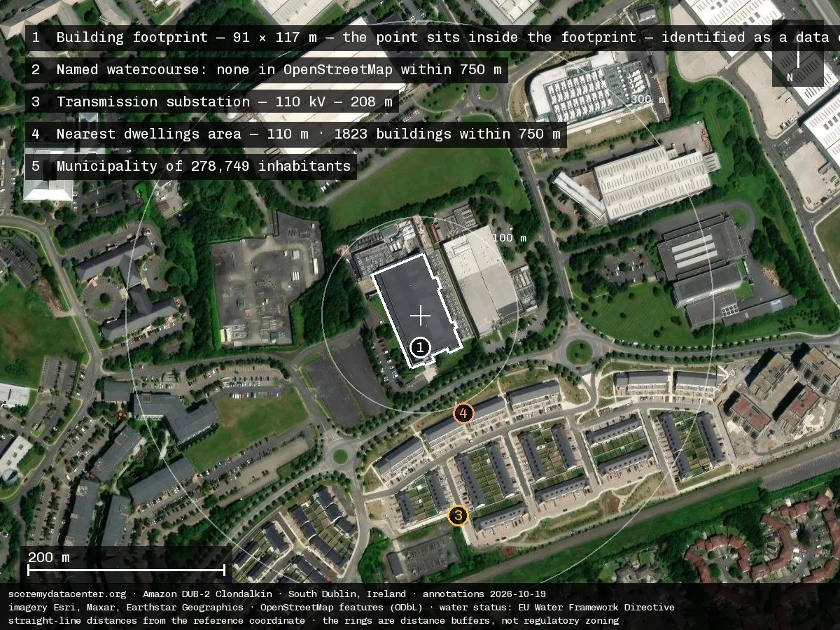
This site is among the 100% of the fleet connected to an already-saturated substation. Fleet figures →
This site is in Ireland — the country's site index: C (54.9). See the country index →
Tracked indicators
| Indicator | Value | Reading | State | Source |
|---|---|---|---|---|
| Energy | ||||
| Local grid carbon intensity How much CO₂ is emitted to produce the electricity the site will consume, based on the regional grid. The lower the value, the better. | 194.5 gCO2e/kWh | Measured | EirGrid Smart Grid Dashboard — ROI grid CO2 intensity, mean 2026-07-05..2026-07-12 (194.5 gCO2/kWh, n=673 half-hourly). energy-charts does not serve the Irish zone — accessed 2026-07-12 | |
| Grid connection capacity / proximity How easily the site can be connected to the power grid: available capacity and distance to the nearest substation. | grid saturated at the connection point | Measured | CRU/EirGrid Dublin-region data-centre grid-connection moratorium (CRU/21/124 & successors) — the Greater Dublin grid is constrained; new DC connections are restricted/withheld. Zonal capacity signal from the published policy — accessed 2026-07-12 | |
| Grid congestion / connection queue How congested the local grid is: the more saturated, the more the connection competes with other users. | critical local grid congestion | Measured | CRU/EirGrid Dublin-region data-centre grid-connection moratorium (CRU/21/124 & successors) — the Greater Dublin grid is constrained; new DC connections are restricted/withheld. Zonal capacity signal from the published policy — accessed 2026-07-12 | |
| PUE (announced energy efficiency) The announced energy efficiency: total electricity used versus what actually powers computing. Closer to 1 is better. The lower the value, the better. | — | — | Not looked for yet We have not looked for this yet. It is dropped from the calculation and does not penalise the site. | — |
| Heat-network connectability Whether the site can valorise its waste heat via a district-heating network: distance to the nearest network and presence of a connection obligation (priority development perimeter). | — | — | Not looked for yet We have not looked for this yet. It is dropped from the calculation and does not penalise the site. | — |
| Waste-heat recovery — commitment Operator commitment level to valorise the site's waste heat (delivered / signed contract / study / intention / none). | — | — | Not looked for yet We have not looked for this yet. It is dropped from the calculation and does not penalise the site. | — |
| Water | ||||
| Local water stress Water tension in the area: in an already water-scarce region, withdrawals weigh more heavily. | no measured water stress in the area | Measured | WRI Aqueduct 4.0 baseline water stress at point — 'Low - Medium (10-20%)' (bws_cat 1/4) — accessed 2026-07-12 | |
| Water body status The ecological health of the affected river or aquifer, per the EU classification (from 'high' to 'bad'). | water body in moderate status | Measured | EEA WISE spatial (WFD 2022) — nearest water body IEEA_09C020250 'CAMAC020' at point + WISE ecological status class 3/5 — accessed 2026-07-12 | |
| Basin withdrawal pressure How intensively water is already withdrawn from the basin: a heavily-tapped basin ill affords a new user. | — | — | Not looked for yet We have not looked for this yet. It is dropped from the calculation and does not penalise the site. | — |
| Cooling technology + announced water volume The cooling technology chosen and the water volume it will consume, as announced by the operator. | — | — | Not looked for yet We have not looked for this yet. It is dropped from the calculation and does not penalise the site. | — |
| Land & biodiversity | ||||
| Overlap / distance to protected areas How close the project is to protected natural areas (Natura 2000, nature reserves…). | protected natural area 1–5 km away | Measured | EEA Natura2000Sites (Habitats+Birds combined) — overlap by distance ring (IE0001209) — accessed 2026-07-12 | |
| Soil status (artificialized / natural / agricultural) What the land was before: already built (brownfield), natural, or farmland — sealing farmland or nature weighs most. | previously developed land | Measured | Corine Land Cover 2018 (EEA) — CLC code 121 at point — accessed 2026-07-12 | |
| Ecological corridors (TVB) Whether the project severs a wildlife corridor (green-and-blue network). | Not disclosed | — | Absent from the file We read the public file and the information is not in it. It counts as a zero in the grade. | — |
| Site ground footprint The SITE's ground footprint in hectares — the land the project takes up (buildings, roads, parking, substation, retention basins), not the building print alone: the larger, the greater the land impact. The lower the value, the better. | — | — | Not looked for yet We have not looked for this yet. It is dropped from the calculation and does not penalise the site. | — |
| Avoid-reduce-offset (ERC) measures Measures to avoid, reduce or offset harm to soil artificialisation and biodiversity. (Heat recovery moved to E6/E7, Energy pillar.) | — | — | Not looked for yet We have not looked for this yet. It is dropped from the calculation and does not penalise the site. | — |
| Designated for urbanisation in a supra-municipal plan not scored · contextual fact Is the site designated for urbanisation in a planning document above the municipality? A contextual fact, published as such: it neither improves nor worsens the grade. | — | — | Not looked for yet We have not looked for this yet. It is dropped from the calculation and does not penalise the site. | — |
| Planning-document compatibility procedure under way not scored · contextual fact Is a procedure under way to make the planning document compatible with the project? A contextual fact: we follow the instrument, not the intention — the land status only changes the day the procedure completes. | — | — | Not looked for yet We have not looked for this yet. It is dropped from the calculation and does not penalise the site. | — |
| Local impact | ||||
| Municipality socio-economic profile The host town's social profile. A safeguard: a project must never improve its grade by locating in a vulnerable town. | — | — | Not looked for yet We have not looked for this yet. It is dropped from the calculation and does not penalise the site. | — |
| Absorption capacity (project size vs municipality) The project's size relative to the town: a very large project in a small town disrupts more. The lower the value, the better. | Not disclosed | — | Absent from the file We read the public file and the information is not in it. It counts as a zero in the grade. | — |
| Technological hazard / nearby Seveso sites The presence of hazardous industrial sites (Seveso) nearby, adding risk to the surroundings. | — | — | Not looked for yet We have not looked for this yet. It is dropped from the calculation and does not penalise the site. | — |
| Announced jobs The number of permanent jobs announced, relative to project size. More is better. The higher the value, the better. | — | — | Not looked for yet We have not looked for this yet. It is dropped from the calculation and does not penalise the site. | — |
| Announced tax revenue The tax revenue the project would bring to the town, as announced. | — | — | Not looked for yet We have not looked for this yet. It is dropped from the calculation and does not penalise the site. | — |
| Observed level of opposition The scale of observed opposition: appeals, petitions, mobilizations reported by the press. | Not disclosed | — | Absent from the file We read the public file and the information is not in it. It counts as a zero in the grade. | — |
| Elected officials' position (voted facts only) Elected officials' position as expressed by official votes only (council decisions), with no personal judgment. | Not disclosed | — | Absent from the file We read the public file and the information is not in it. It counts as a zero in the grade. | — |
| Transparency & governance | ||||
| Consultation / consent / governance (procedural proxies) The quality of the democratic process: public inquiry held, environmental authority opinion, appeals, CNDP referral. | — | — | Not looked for yet We have not looked for this yet. It is dropped from the calculation and does not penalise the site. | — |
| Documentation transparency / file availability How genuinely accessible the project's file is to the public: published studies, figures and commitments. | — | — | Not looked for yet We have not looked for this yet. It is dropped from the calculation and does not penalise the site. | — |
Operator response
The operator can send us a response about this datasheet. When a response is received and publishable, it appears here, clearly attributed and dated.
A factual error? Use “Report an error”, attaching a source or supporting document.
State of the available data
26 indicators tracked · 7 measured · 0 announced (unverified) · 4 absent from the file · 15 not looked for yet.